


more information on data transmission charges,
contact your service provider.
The maps are automatically saved on a compatible
memory card (if inserted and set as the default
maps storage).
To zoom in or out, press * or #. Use the scale bar to
estimate the distance between two points on the
map.
Adjust the map view
To define the metric system used in the maps, select
Options > Tools > Settings > Map > System
of measurement > Metric or Imperial.
To define what kinds of points of interest are shown
on the map, select Options > Tools > Settings >
Map > Categories and the desired categories.
To select whether you want to view maps in 2-D
mode, 3-D mode, as satellite image, or hybrid, select
Options > Map mode > Map, Map 3D,
Satellite, or Hybrid. Satellite images may not be
available for all geographic locations.
To define whether you want the map view to be a
day view or a night view, select Options > Tools >
Settings > Map > Colours > Day mode or Night
mode.
To adjust other internet, navigation, routing, and
general map settings, select Options > Tools >
Settings.
Download maps
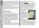
When you browse a map on the display in Maps, a
new map is automatically downloaded if you scroll
to an area which is not covered by maps already
downloaded. You can view the amount of
transferred data from the data counter (kB) shown
on the display. The counter shows the amount of
network traffic when you browse maps, create
routes, or search for locations online. Downloading
maps data may involve the transmission of large
amounts of data through your service provider’s
network. Contact your service provider for
information about data transmission charges.
To prevent the device from automatically
downloading maps through the internet, for
example, when you are outside your home cellular
network, or other map related data required by the
extra services, select Options > Tools >
Settings > Internet > Go online at start-up >
No.
To define how much memory card space you want
to use for saving maps or voice guidance files, select
Options > Tools > Settings > Map >
Maximum memory use > Max. memory card
use. This option is available only when a compatible
memory card is inserted and set as the default maps
storage. When the memory is full, the oldest map
59
Maps