14 nüvi 2585TV Owner’s Manual
• Select Public Transit to calculate a route
that combines public transit and walking.
NOTE: You must have cityXplorer
™
maps
loaded to navigate using public transit
(page 20).
5
If necessary, select a route.
Previewing Multiple Routes
1
Search for a location (page 8).
2
From the search results, select a location.
3
Select Routes.
4
Use the on-screen buttons to select a route.
5
Select Go!.
Automobile Routes
The route is marked with a magenta line. A
checkered ag marks your destination.
As you travel, the device guides you to the
destination with voice prompts, arrows on the map,
and directions at the top of the map. If you depart
from the original route, the device recalculates the
route and provides new directions.
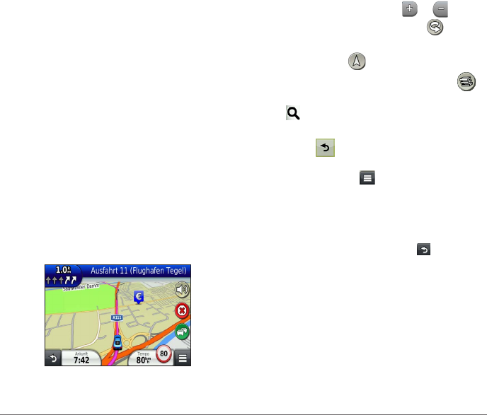
Using the Navigation Map
1
From the main menu, select View Map.
2
If the zoom controls are hidden, select the map
to display the zoom controls.
3
Select the map to switch to browsing mode.
Map buttons appear.
4
Select an option:
• To zoom in or out, select
or .
• To rotate the map view, select
.
• To switch between North Up and 3-D
views, select
.
• To add or remove map layers, select
.
• To view specic location categories, select
and select a category icon.
• To center the map on your current location,
select
.
• To view shortcuts for map and navigation
features, select
.
Adding a Point to a Route
Before you can add a stop to a route, you must be
navigating a route in Automobile mode.
1
While navigating a route, select to return to
the main menu.
2
Select Where To?.
3
Search for the location (page 8).
4
Select Go!.
5
Select Add to Active Route.


