Page 4-12 400 SERIES INSTALLATION MANUAL
Page Rev L P/N 190-00140-02
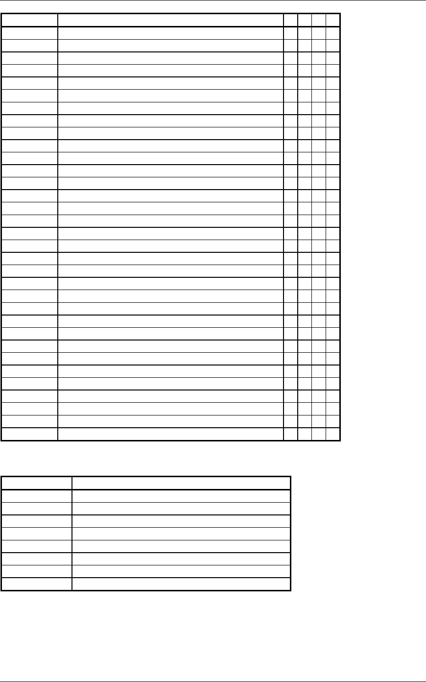
Label # Parameter Name 1234
251 Distance to Go •
251G Distance to Go • • •
252 Time to Go ••••
260G Date (BCD) • • •
261G GPS Discrete Word 1 • • •
275G LRN Status Word • • •
300G Station Declination, Type, and Class • • •
303 Message Length/Type/Number • • •
304G Message Characters 1-3 • • •
305G Message Characters 4-6 • • •
306G NAV/Waypoint/Airport Latitude • • •
307G NAV/Waypoint/Airport Longitude • • •
310 Present Position Latitude ••••
311 Present Position Longitude ••••
312 Ground Speed ••••
313 Track Angle (True) ••••
314 True Heading ••••
315 Wind Speed ••••
316 Wind Angle (True) ••••
320 Magnetic Heading ••••
321 Drift Angle ••••
326G Lateral Scale Factor • • •
330 Conic Arc Inbound Course • •
331 Conic Arc Radius • •
332 Conic Arc Course Change Angle • •
333 Airport Runway Azimuth • •
334 Airport Runway Length in Feet • •
335 Left/Right Hand Holding Pattern Azimuth • •
340 Left/Right Hand Procedure Turn Azimuth • •
351G Distance To Destination (Via Flight Plan) • • •
352G Estimated Time To Destination (Via Flight Plan) • • •
371G Specific Equipment ID • • •
377 Equipment Hex ID Code ••••
The following labels are output on the VOR/ILS ARINC 429 OUT port:
Label # Parameter Name
034G VOR/ILS Frequency (BCD)
035G DME Frequency (BCD)
100G Selected Course #1
173 Localizer Deviation
174 Glideslope Deviation
222 VOR Omnibearing
371G Specific Equipment ID
377 Equipment Hex ID Code
The labels recognized on the GPS ARINC 429 IN 1 or GPS ARINC 429 IN 2 ports depend on the
configuration (refer to section 5.2.1).
The 400 Series unit can receive traffic data from a BF Goodrich SKY497 Skywatch system using the GPS
ARINC 429 IN 1 or GPS ARINC 429 IN 2 lines, in order to display traffic information on the 400 Series
unit.


