


3 If a new map version or new voice files are available for your device, you
are prompted to update the data.
4 Select a continent and a country. Larger countries may have several sub-
maps so you can download the maps relevant for you.
5 Select the maps, and download and install them to your device.
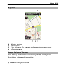
About positioning methods
Maps displays your location on the map using GPS, A-GPS, or cell ID based
positioning.
The Global Positioning System (GPS) is a satellite-based navigation system
used for calculating your location. Assisted GPS (A-GPS) is a network service
that sends you GPS data, improving the speed and accuracy of the
positioning.
When you use Maps for the first time, you are prompted to define an internet
access point to download map information or use A-GPS.
indicates the availability of the satellite signals. One bar is one
satellite. When the device is searching for satellite signals, the bar is yellow.
When there is enough data available to calculate your location, the bar turns
green. The more green bars, the more reliable the location calculation.
The Global Positioning System (GPS) is operated by the government of the
United States, which is solely responsible for its accuracy and maintenance.
The accuracy of location data can be affected by adjustments to GPS satellites
made by the United States government and is subject to change with the
United States Department of Defense civil GPS policy and the Federal
Radionavigation Plan. Accuracy can also be affected by poor satellite
geometry. Availability and quality of GPS signals may be affected by your
location, buildings, natural obstacles and weather conditions. GPS signals
Maps 131
© 2010 Nokia. All rights reserved.