


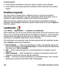

You can sort your landmarks into preset categories, and create new categories. To
edit and create new landmark categories, open the categories tab, and select
Options > Edit categories.
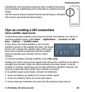
GPS data
GPS data is designed to provide route guidance information to a selected
destination and traveling information, such as the approximate distance to the
destination and approximate duration of travel. You can also view position
information about your current location.
Select Menu > Applications > Location and GPS data.
Positioning settings
Select Menu > Applications > Location and Positioning.
Positioning methods
Select from the following:
● Integrated GPS — Use the integrated GPS receiver of your device.
● Assisted GPS — Use Assisted GPS (A-GPS) to receive assistance data from an
assistance data server.
● Bluetooth GPS — Use a compatible external GPS receiver with Bluetooth
connectivity.
● Network based — Use information from the cellular network (network service).
Positioning server
To define an access point and positioning server for network-assisted positioning
methods, such as assisted GPS or network-based positioning, select Positioning
server. The positioning server may be preset by your service provider, and you may
not be able to edit the settings.
Notation settings
To select which measurement system you want to use for speeds and distances,
select Measurement system > Metric or Imperial.
Positioning (GPS)
© 2010 Nokia. All rights reserved. 107