


Viewing your photos on a map
If you enable location detection when taking photos, you can use the information
gathered at a later stage. For example, you can view your photos on a map and show
friends and family where you were when you took the photo. Adding location
information is also referred to as geotagging. When you enable location detection,
you can select to use either GPS satellites or wireless networks, or both, to find your
position.
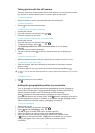
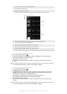
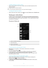
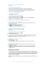
Overview of Maps tab
1 The number of geotagged photos and videos.
2 Double tap to zoom in. Pinch to zoom out. Drag to view different parts of the map.
3 A group of photos and/or videos geotagged with the same location.
4 Thumbnails of the selected group of photos and/or videos. Tap an item to view it in full screen.
5 Search a location on the map.
6 Switch to globe view.
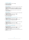
To enable location detection
1
From your Home screen, tap
.
2
Find and tap Settings > Location services.
3
Mark the GPS satellites and/or Google's location service checkboxes.
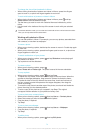
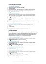
To view geotagged photos on a map in Album
1
From your Home screen, tap .
2
Find and tap Album > Maps.
3
Tap a photo to view it in full screen.
4
If several photos were taken at the same location, only one of them appears on
the map. The total number of photos appears in the top right corner, for
example, . To view these photos, tap the cover photo and then tap one of the
thumbnails at the bottom of the screen.
When viewing a geotagged photo in the photo viewer, you can touch the screen to display the
toolbars, then tap
to view the photo on the map.
To add a geotag when viewing the map in Album
1
When viewing the map in Album, press
, then tap Add geotag.
2
Find and tap the photo to which you want to add the geotag.
3
Tap the desired location on the map to set the geotag, then tap OK.
76
This is an Internet version of this publication. © Print only for private use.