


About positioning methods
Maps displays your location on the map using GPS, A-GPS, or cell ID based
positioning.
The Global Positioning System (GPS) is a satellite-based navigation system used for
calculating your location. Assisted GPS (A-GPS) is a network service that sends you
GPS data, improving the speed and accuracy of the positioning.
When you use Maps for the first time, you are prompted to define an internet access
point to download map information or use A-GPS.
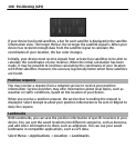
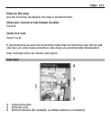
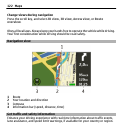
indicates the availability of the satellite signals. One bar is one satellite.
When the device is searching for satellite signals, the bar is yellow. When there is
enough data available to calculate your location, the bar turns green. The more
green bars, the more reliable the location calculation.
The Global Positioning System (GPS) is operated by the government of the United
States, which is solely responsible for its accuracy and maintenance. The accuracy
of location data can be affected by adjustments to GPS satellites made by the United
States government and is subject to change with the United States Department of
Defense civil GPS policy and the Federal Radionavigation Plan. Accuracy can also be
affected by poor satellite geometry. Availability and quality of GPS signals may be
affected by your location, buildings, natural obstacles, and weather conditions. GPS
signals may not be available inside buildings or underground and may be impaired
by materials such as concrete and metal.
GPS should not be used for precise location measurement, and you should never
rely solely on location data from the GPS receiver and cellular radio networks for
positioning or navigation.
The trip meter has limited accuracy, and rounding errors may occur. Accuracy can
also be affected by availability and quality of GPS signals.
With cell ID based positioning, the position is determined through the antenna
tower your cellular phone is currently connected to.
Maps 115