30
Getting Started
Main Page Sequence
30
Reference
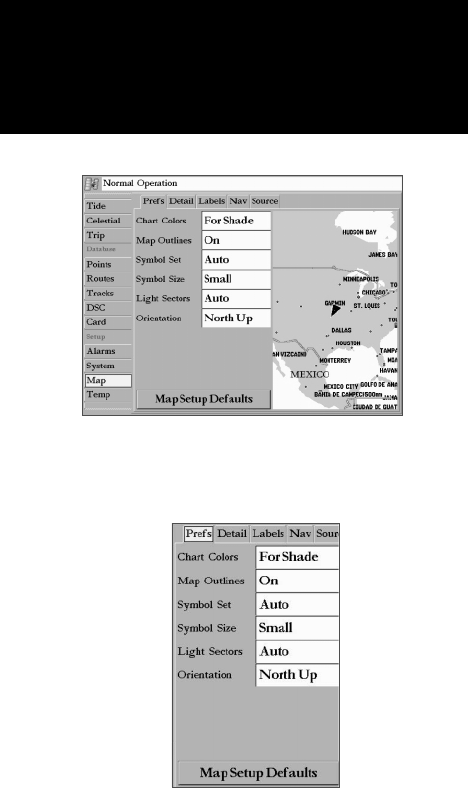
• Setup ( Map Setup) — allows you to confi gure the map display to your preferences, including map
detail, map orientation, automatic zoom, and various map items and points. When you choose the Map
Setup option, the vertical list of Main Menu tabs (see pg. 55) displays, with the ‘Map’ tab already selected.
The Setup options are arranged in a horizontal, easy to use ‘submenu tab’ format, making it easier to orga-
nize the various settings for ease of use. Changes made from the Map Setup affects all Maps. The following
table lists the submenu tabs and the settings available under each tab:
Prefs Chart Colors, Map Outlines, Symbol Set, Symbol Size, Light Sectors, Orientation
Detail Chart, Waypoints, Active Route, Tide Stations, Services, Saved Tracks, Track Log,
Spot Soundings, Lat/Lon Grid
Labels Chart, Waypoints, Active Route, Tide Stations, Services, Spot Soundings, Lat/Lon Grid
Nav AutoZoom, Accuracy Circle, Bearing Line, Course Line, Heading Line
Source Basemap, Card Maps, Advanced Setup
To change a Setup feature:
1. Select the ‘Setup’ Adjustment or press the ‘Map Setup’ SOFT KEY.
2. Move LEFT or RIGHT on the ARROW KEYPAD to highlight the desired submenu tab, then UP or DOWN on
the ARROW KEYPAD to highlight the setting you want to change and press ENTER.
3. Move UP or DOWN on the ARROW KEYPAD to highlight to the desired setting and press ENTER or press
the associated DATA ENTRY shortcut key. To exit, press QUIT.
Prefs Tab
Chart Colors— For Shade/For Sun: “For Shade” is designed to match the color of physical marine
charts as closely as possible. Use this setting when in shaded environments. “For Sun” displays more
vibrant colors for use in sunny environments. BlueChart data may be used with either mode.
Map Outlines— On/Off: toggles the coverage boxes for BlueChart/MapSource data “On” and “Off”.
Symbol Set— Auto, Garmin, NOAA, International: controls the desired navaid symbol set.
Auto - BlueChart maps are drawn using symbols similar to the NOAA/NIMA standard.
Non BlueChart maps are drawn using traditional Garmin symbols.
Garmin - All maps are drawn using traditional Garmin symbols.
NOAA - All maps are drawn using a symbol set similar to NOAA/NIMA.
Prefs Tab
Main Menu—Map Confi guration Tab
Map Page Options


