59
Getting Started
Main Page Sequence
59
Reference
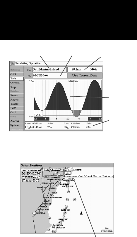
with the time progressing from left to right. (Sunrise/sunset info may not be available for a few stations).
The solid, light vertical lines are in 4-hour increments, and the light, dotted vertical lines are in 1-hour
increments. A solid, vertical line (with the current time box at the top) indicates the time of day when
using current date and intersects the tide graph to show their relation.
The tide curve shows as a shaded area, with higher tides being taller (blue) and lower tides shorter
(red). The solid, horizontal line (with the current tide box on the left) indicates the current tide height.
The fi gure to the left of the line shows the current tide level. The Mean Lower Low Water (MLLW) appears
as a solid, horizontal line near the bottom of the chart (This line only appears if the tide ranges to the zero
value or below). The numbers on the top and bottom of the left side indicate the maximum/minimum
levels. The four data fi elds below the chart, indicate event times and levels at which the tide changes start-
ing in the upper left fi eld, going downward, then to the upper right and down again. When comparing
with other tide tables, be sure the depth unit value is the same for both sources.
To select the nearest tide station from you current location:
1. From the “Tide” tab, highlight the ‘For’ fi eld and press ENTER.
2. Highlight ‘Current Position’ and press ENTER.
3. Highlight the desired station of the list and press ENTER. As you move the cursor over each station, it
highlights on the Map window to show its location. The distance and bearing from your current position to
the highlighted station appears at the bottom of the list
If you are not within this range, you see a message “None Found”. Use the ‘Map Position’ option and
select a location closer to a tide station.
To select a tide station from the map:
1. From the “Tide” tab, highlight the ‘For’ fi eld and press ENTER.
or Press FIND from any page, then highlight ‘Tidal Information’ and press ENTER.
2. Highlight ‘Map Position’ and press ENTER.
3. Select a position on the map and press ENTER.
4. A list appears showing the nearest tide stations. Highlight the desired station and press ENTER. If the
“None Found” message appears, repeat steps 1-4 until you fi nd a station.
Event Times
Tide Chart
Main Menu—Tide Tab
Station Name Date
You may select a tide station from a
Map position
Main Menu: Tide Tab
Distance and Bearing


