


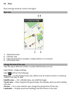

Night mode — Dim the colours of the map. When travelling at night, the map is easier
to read in this mode.
Transit lines — View selected public transport services, such as metro and tram
routes.
The available options and features may vary by region. The unavailable options are
dimmed.
About positioning methods
Maps shows your location on the map using GPS, A-GPS, or network (cell ID) based
positioning.
A-GPS and other enhancements to GPS may require transferring small amounts of
data over the cellular network.
GPS The global positioning system (GPS) is a navigation system that
uses satellites to work out where you are.
A-GPS The Assisted GPS (A-GPS) network service retrieves location
information using the cellular network, and assists GPS in
calculating your current location.
Your phone is set up to use the Nokia A-GPS service, unless your
network service provider has its own A-GPS settings. To get the
assistance data to your phone, you need to be able to connect to
the internet. Your phone gets the data from the service only when
needed.
Cell ID With network (cell ID) based positioning, Maps locates you
through the cellular system your phone is currently connected to.
The availability and quality of GPS signals may be affected by your location, satellite
positions, buildings, natural obstacles, weather conditions, and adjustments to GPS
satellites made by the United States government. GPS signals may not be available
inside buildings or underground.
Do not use GPS for precise location measurement, and never rely solely on the
location info provided by GPS and cellular networks.
The trip meter may not be accurate, depending on the availability and quality of your
GPS connection.
Depending on the available positioning methods, the accuracy of positioning may
vary from a few metres to several kilometres.
Maps 69