


Rev 3.0B Feb.08 83
10
10: Global Positioning System
(GPS)
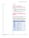
• Configuring the
PinPoint X for GPS
• RAP Configuration
• NMEA Configuration
• TAIP Emulation
Configuration
ThePinPointXisequippedwithaGlobalPositioningSystem
receiver(GPS)toascertainitspositionandtrackthe
movementsofavehicleorotherdeviceswhichmove.The
PinPointXrelaystheinformationofitslocationaswellas
otherdataforusewithtrackingapplications.
TrackingApplicationsusedwithSierraWirelessPinPointline
modems:
• Air‐Trak
• TrackYourTruck
• TrackStar
• DeLormeStreetAtlasUSA
• MicrosoftStreetsandTrips
• CompassCom
• ZollData
• andmanymore...
GPS Overview
TheGlobalPositioningSystem(GPS)isasatellitenavigation
systemusedfordeterminingalocationandprovidingahighly
accuratetimereferencealmostanywhereonEarth.TheUS
militaryreferstoGPSasNavigationSignalTimingand
RangingGlobalPositioningSystem(NAVSTARGPS).
GPSconsistsofa“constellation”ofatleast24satellitesin6
orbitalplanes.EachsatellitecirclestheEarthtwiceeveryday
atanaltitudeof20,200kilometers(12,600miles).Eachsatellite
isequippedwithanatomicclockandconstantlybroadcasts
thetime,accordingtoitsownclock,alongwithadministrative
informationincludingtheorbitalelementsofitsmotion,as
determinedbyground‐basedobservatories.
AGPSreceiver,suchasthePinPointX,requiressignalsfrom
fourormoresatellitesinordertodetermineitsownlatitude,
longitude,andelevation.Usingtimesyncedtothesatellite
system,thereceivercomputesthedistancetoeachsatellite