


Maps
Ovi Maps
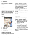
Maps overview
Select > Maps.
Welcome to Maps.
Maps shows you what is nearby, helps you
plan your route, and guides you where
you want to go.
• Find cities, streets, and services.
• Find your way with turn-by-turn
directions.
• Synchronise your favourite locations
and routes between your mobile
device and the Ovi Maps internet
service.
• Check weather forecasts and other
local information, if available.
Note: Downloading content such as
maps, satellite images, voice files, guides
or traffic information may involve
transmission of large amounts of data
(network service).
Some services may not be available in all
countries, and may be provided only in
selected languages. The services may be
network dependent. For more
information, contact your network service
provider.
Almost all digital cartography is
inaccurate and incomplete to some
extent. Never rely solely on the
cartography that you download for use in
this device.
Content such as satellite images, guides,
weather and traffic information and
related services are generated by third
parties independent of Nokia. The content
may be inaccurate and incomplete to
some extent and is subject to availability.
Never rely solely on the aforementioned
content and related services.
About positioning methods
Maps displays your location on the map
using GPS, A-GPS, or cell ID based
positioning.
The Global Positioning System (GPS) is a
satellite-based navigation system used
for calculating your location. Assisted GPS
(A-GPS) is a network service that sends you
GPS data, improving the speed and
accuracy of the positioning.
When you use Maps for the first time, you
are prompted to define an internet access
point to download map information or
use A-GPS.
indicates the availability of
the satellite signals. One bar is one
satellite. When the device is searching for
satellite signals, the bar is yellow. When
there is enough data available to calculate
your location, the bar turns green. The
more green bars, the more reliable the
location calculation.
The Global Positioning System (GPS) is
operated by the government of the United
States, which is solely responsible for its
accuracy and maintenance. The accuracy
of location data can be affected by
adjustments to GPS satellites made by the
United States government and is subject
to change with the United States
Department of Defense civil GPS policy and
the Federal Radionavigation Plan.
54 Positioning
© 2010 Nokia. All rights reserved.