2 - NAV PAGES
57
190-00357-00 Rev C
Each satellite has a 30-second data transmission
that must be collected (hollow signal strength bar)
before the satellite may be used for navigation (solid
signal strength bar). Once the GPS receiver has deter-
mined your position, the 500W-series unit indicates
your position, altitude, track and ground speed. The
GPS receiver status field also displays the following
messages under the appropriate conditions:
•Searching Sky —
The GPS receiver is searching the sky for ANY vis-
ible satellites. You are also informed of this status
with a “Searching the Sky” message.
•AcquiringSat —
The GPS receiver is acquiring satellites for naviga-
tion. In this mode, the receiver uses satellite orbital
data (collected continuously from the satellites) and
last known position to determine the satellites that
should be in view.
•3DNavigation —
TheGPSreceiverisin3Dnavigationmodeand
computes altitude using satellite data.
•3DDifferentialNavigation—TheGPSreceiveris
in3Dnavigationmodeanddifferentialcorrections
are being used.
The Satellite Status Page also indicates the accu-
racy of the position fix, using Horizontal Figure of
Merit (HFOM),VerticalFigureofMerit(VFOM), and
Estimated Position Uncertainty (EPU). HFOM and
VFOMrepresentthe95%condencelevelsinhori-
zontal and vertical accuracy. The lowest numbers are
the best accuracy and the highest numbers are worse.
EPU is the horizontal position error estimated by the
FaultDetectionandExclusion(FDE) algorithm, in feet
or meters.
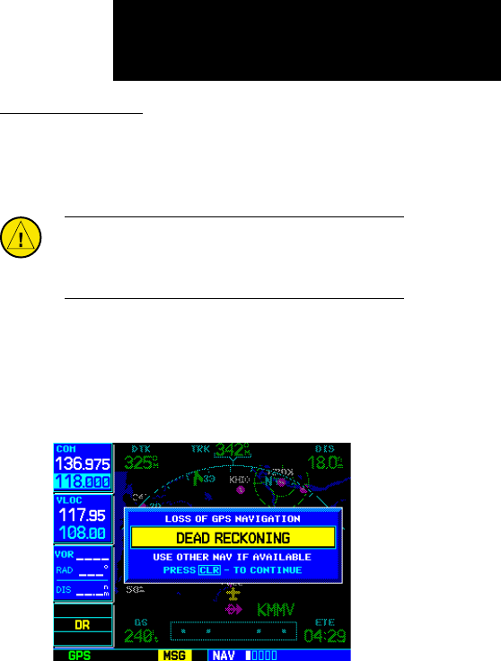
Dead Reckoning
Deadreckoningistheprocessofcontinuingnavi-
gation using your last known position and speed after
a loss of GPS navigation while on an active flight plan.
CAUTION: Navigation using dead reckoning is there-
fore only an estimate and should not be used as the
sole means of navigation. Use other means of naviga-
tion, if possible.
DeadreckoningbecomesactiveafteralossofGPS
position while you are navigating using an active flight
plan.
A pop-up message will appear and you must clear
the message before continuing operation.
The ownship icon color is changed to yellow. The To/
FromagisremovedfromtheCDI.TheDeadReckon-
ingannunciator(DR)appearsontheleftsideofthe
map display when GPS position is unavailable and the
unitisinDeadReckoningmode.Allexternaloutputs
dependent on GPS position are flagged.
Terrain will be noted as not available and new terrain
advisory pop-ops will not occur. Traffic and Storm-
scope information will not be shown on the Map page,
but will continue to be available on their own dedi-
catedpages.XMweatherwillstillbeavailableonthe
Map page.
Dead Reckoning


