


GPS data
Select Menu > GPS > GPS data.
With GPS data, you can view your current location, find your
way to a desired location, and track distance.
Select Navigation to view navigating information to your
trip destination, Position to view positioning information
about your current location, or Trip dist. to view your
travelling information such as the distance and duration you
have travelled, and your average and maximum speeds.
The application must receive positioning information from at
least four satellites to be used as a travelling aid.
The trip meter has limited accuracy, and rounding errors may
occur. Accuracy can also be affected by availability and quality
of GPS signals.
Use GPS data
To check the signal strength of the satellites that provide the
positioning information necessary for navigation, open any
of the three views and select Options > Satellite status.
To set a landmark or location as the destination of your trip,
select Navigation > Options > Set destination. You can
also enter the destination latitude and longitude
coordinates.
To remove the destination set for your trip, select
Navigation > Options > Stop navigation.
To save your current position as a landmark, select
Navigation or Position, and Options > Save position.
To activate the trip meter, select Trip distance > Options >
Start. To stop the trip meter, select Options > Stop.
To reset all fields and start calculating the trip again, select
Trip distance > Options > Restart.
To change the measuring system in use, select Options >
Settings > Measurement system > Metric or Imperial.
To enter the altitude calibration to correct the altitude
received from the positioning satellites, select Options >
Settings > Altitude calibration.
Landmarks
Select Menu > GPS > Landmarks.
Landmarks are coordinates to geographic locations that you
can save to your device for later use in different location-
based services. You can create landmarks using the internal
GPS receiver of your device or network (network service).
Create a landmark
To create a landmark, select Options > New landmark.
Select Current position to make a network request for the
latitude and longitude coordinates of your current location,
Select from map to select the location from a map, or Enter
manually to fill in necessary location information such as a
name, category, address, latitude, longitude, and altitude.
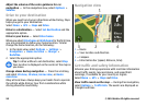
To show the landmark on the map, select Options > Show
on map.
© 2010 Nokia. All rights reserved. 93