45
Main Pages
Change Data Fields – allows you to specify the type of data displayed in each data fi eld on the page.
Refer to the Appendix for a complete list of all data fi elds used in the GPSMAP 276C.
Data Card Information – shows information about the detailed map data stored on the data card, and
allows you to select which maps are displayed or not displayed on the Map Page.
To measure the Bearing/Distance between two points:
1. Highlight the ‘Measure Distance’ option and press ENTER/MARK. An on-screen pointer appears on
the map display at your present position with ‘ENT REF’ below it. A push-pin icon is placed at your
present location.
2. Move the cursor to the desired reference point (the point that you want to measure to). Notice the
bearing and distance displayed in the data window at the top of the display.
To start measuring from a different location, use the Arrow Keypad to pan to the location and press
ENTER/MARK. The push-pin icon marks the map cursor’s location. Again, move the cursor to the
point to which you want to measure. The bearing and distance from the reference point and cursor
coordinates are displayed in the data window.
3. Press the
QUIT key to fi nish.
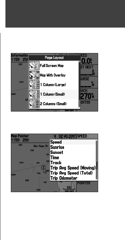
To set up the page layout:
1. Highlight ‘Set Up Page Layout’ from the Options Menu and press ENTER/MARK.
2. Select the desired option and press
ENTER/MARK.
To change a data fi eld display:
1. From the Options Menu, highlight ‘Change Numbers’ and press ENTER/MARK.
2. Move the fi eld highlight to the data fi eld you want to change and press
ENTER/MARK.
3. Press UP or DOWN on the
ARROW KEYPAD to highlight the data you want to display, and press
ENTER/MARK.
4. Press
QUIT to exit.
Map Page
Map Page Layout Options ( Marine Mode)
Changing a Data Field
190-00335-00_0A.indd 45 4/7/2004, 1:50:39 PM


