49
Main Pages
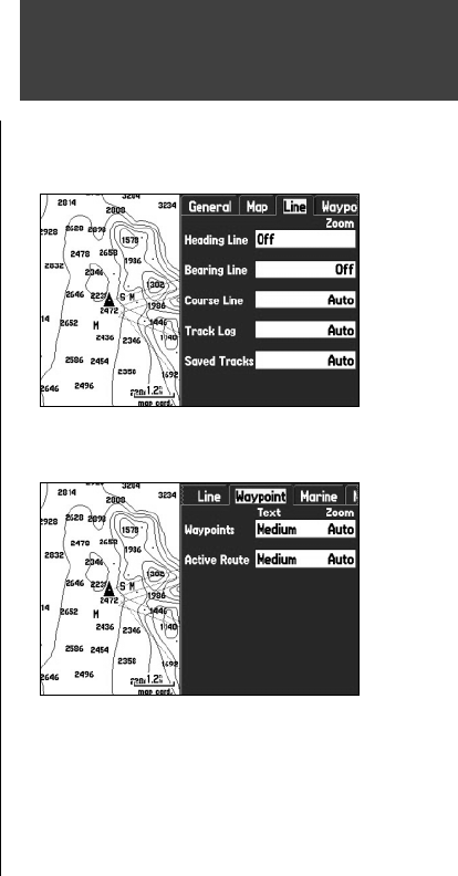
‘ Line’ tab
Heading Line – Off, Distance, Time: turns the Heading Line off, or confi gures it for distance or time.
The Heading Line projects (using time or distance) from the position marker (triangle vehicle icon) show-
ing your current heading.
Bearing Line – Auto, Off, 20 ft. to 800 nm/mi: sets the maximum scale at which the Bearing Line ap-
pears on the screen. The Bearing Line shows the bearing from your current location to a
destination waypoint.
Course Line – Auto, Off, 20 ft. to 800 nm/mi: sets the maximum scale at which the Course Line appears
on the screen. The Course Line shows a direct navigation line from the point navigation was initiated to
a destination waypoint.
Track Log – Auto, Off, 20 ft. to 800 nm/mi: sets the maximum scale at which the track log appears on
the screen. Some types of data are only displayed to certain zoom scales.
Saved Tracks – Auto, Off, 20 ft. to 800 nm/mi: sets the maximum scale at which saved tracks appear on
the screen. Some types of data are only displayed to certain zoom scales.
‘Waypoint’ tab
Waypoints, Active Route – controls the text size and zoom scale for waypoints and active routes.
Text – Off, Small, Medium, and Large: controls the screen size of the name.
Zoom – Auto, Off, 20 ft. to 800 nm/mi: sets the maximum scale at which the feature appears on the
screen. Some types of data are only displayed to certain zoom scales.
Map Page
Line Tab of Map Page Setup Menu
Waypoint Tab of Map Page Setup Menu
190-00335-00_0A.indd 49 4/7/2004, 1:50:43 PM


