51
Main Pages
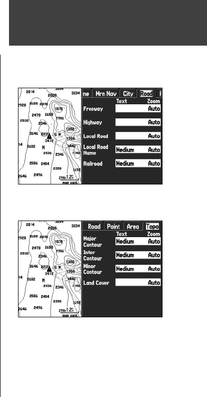
‘ Road’ tab
Freeway, Highway, Local Road, Local Road Name, Railroad – controls the text size and zoom scale
for roads.
Text – Off, Small, Medium, and Large: controls the screen size of the name.
Zoom – Auto, Off, 20 ft. to 800 nm/mi: sets the maximum scale at which the roads appear on the
screen. Some types of data are only displayed to certain zoom scales.
‘Point’ tab
POIs, Geo, Exit – controls the text size and zoom scale for points, such as exits.
Text – Off, Small, Medium, and Large: controls the screen size of the name.
Zoom – Auto, Off, 20 ft. to 800 nm/mi: sets the maximum scale at which the points appear on the
screen. Some types of data are only displayed to certain zoom scales.
‘Area’ tab
River/Lake, Park, Other, Metro – controls the text size and zoom scale for areas such as rivers.
Text – Off, Small, Medium, and Large: controls the screen size of the name.
Zoom – Auto, Off, 20 ft. to 800 mi: sets the maximum scale at which the areas appears on the screen.
Some types of data are only displayed to certain zoom scales.
‘Topo’ tab
Major Contour, Inter Contour, Minor Contour, Land Cover – controls the text size and zoom scale
for topographic contours.
Text – Off, Small, Medium, and Large: controls the screen size of the name.
Zoom – Auto, Off, 20 ft. to 800 nm/mi: sets the maximum scale at which the contours appear on the
screen. Some types of data are only displayed to certain zoom scales.
Map Page
Road Tab of Map Page Setup Menu
Topo Tab of Map Page Setup Menu
190-00335-00_0A.indd 51 4/7/2004, 1:50:45 PM


