


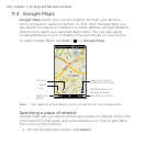
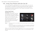

228 Chapter 11 Finding and Recording Places
Using Layers
Layers lets you overlay location-specific information on Google Maps.
You can add multiple layers at a time to create a customized map
containing the specific information you want to view.
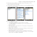
To add a layer
1. On the Google Maps screen, tap Menu and then tap Layers.
2. Tap Browse layers, and then select the layer you want from the
list. You can choose from the following layers:
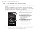
Layer Description
My Maps Shows your custom My Maps created using Google
Maps on your computer. To learn more about My Maps,
go to:
http://maps.google.com/help/maps/mymaps/create.
html.
Wikipedia Shows locations on the map that have associated
Wikipedia articles. Tap the Wikipedia icon marking a
location to view an excerpt of its Wikipedia article. The
excerpt also contains a link to the full article.
Transit Lines Shows public transportation lines for selected cities.
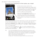
Favorite
Places
Shows favorite places of local experts from cities
around the world. Tap a favorite place on the map
to view a description of the location written by the
local expert. Tap View full description to view more
information about the location.
Latitude
Shows your friends’ locations on the map and lets you
share your location with them. To see a list of your
friends using Latitude, tap See list. To invite friends to
share location information, tap Add friends. To view a
specific friend’s location on the map, tap your friend in
the list, and then tap See map.
Traffic Shows real-time traffic data for selected cities.