


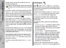
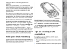
Route guidance uses a rotating compass on the
device display. A red ball shows the direction to the
destination, and the approximate distance to it is
shown inside the compass ring.
Route guidance is designed to show the straightest
route and the shortest distance to the destination,
measured in a straight line. Any obstacles on the
route, such as buildings and natural obstacles, are
ignored. Differences in altitude are not taken into
account when calculating the distance. Route
guidance is active only when you move.
To set your trip destination, select Options > Set
destination and a landmark as the destination, or
enter the latitude and longitude coordinates. Select
Stop navigation to clear the destination set for
your trip.
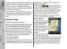
Retrieve position information
Press , and select Tools > Connectivity > GPS
data > Position.
In the position view, you can view the position
information of your current location. An estimate of
the accuracy of the location is displayed.
To save your current location as a landmark, select
Options > Save position. Landmarks are saved
locations with more information, and they can be
used in other compatible applications and
transferred between compatible devices.
Trip meter
The trip meter has limited accuracy, and rounding
errors may occur. Accuracy can also be affected by
availability and quality of GPS signals.
Press
, and select Tools > Connectivity > GPS
data > Trip distance.
Select Options > Start to activate trip distance
calculation, and Stop to deactivate it. The
calculated values remain on the display. Use this
feature outdoors to receive a better GPS signal.
Select Reset to set the trip distance and time and
average and maximum speeds to zero, and to start
a new calculation. Select Restart to set the
odometer and total time to zero.
56
Positioning (GPS)